Department of Construction Engineering and Management
Department of Mechanical and Metallurgical Engineering
Department of Computer Science
A research team at the Pontificia Universidad Católica de Chile (UC) has created a system that assesses runway pavement conditions while allowing air traffic to flow uninterrupted.
Maintaining airports is a critical and complex task. These facilities must operate continuously, 365 days a year, so any intervention must be planned with extreme precision. Maintaining the pavement on runways, taxiways, and aprons is a formidable task: constantly exposed to the elements, battered by severe weather, and pounded by heavy aircraft, the asphalt and concrete suffer relentless wear.
Until now, inspectors and vehicles drove along the runways taking photographs that were later reviewed manually by technical staff. This approach not only requires temporarily halting air traffic, but is also slow, costly, and prone to error because it relies on human visual analysis and flags only the most evident defects.
To overcome these limitations, a team of researchers from UC’s School of Engineering—led by Professor Andrés Prieto and including Álvaro González, Marcelo González, David Acuña, and Rodrigo Toro, is developing an innovative solution based on artificial intelligence (AI) and unmanned aerial vehicles (drones). Their goal is clear: to diagnose pavement deterioration more accurately and in advance, without disrupting airport operations.
How the system works
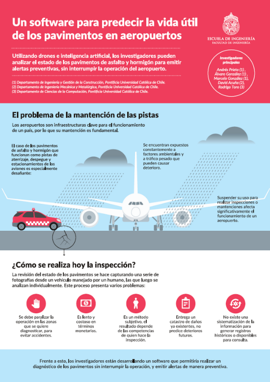
The process begins with gathering historical data from previous inspections commissioned by the Airport Directorate (DAP) of the Ministry of Public Works. Next, camera-equipped drones fly over the runways to capture high-resolution aerial images.
Drones capture aerial photographs without disrupting aircraft traffic.
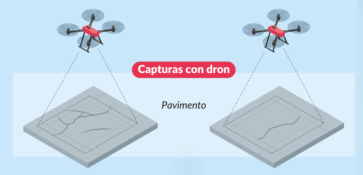
These images are processed by a specialized computer-vision algorithm that detects damage patterns by examining each photograph at the pixel level, spotting damage patterns with a precision no human eye can match. By reading subtle contrasts, it can tell, for example, whether the surface shows advanced wear from aging or the faint beginnings of cracks that could soon become critical.

An algorithm interprets the images captured by the drones. White areas indicate pavement damage.
Using this data, the system calculates the Pavement Condition Index (PCI), the industry-standard score for rating runway health. It also folds in local weather patterns and aircraft traffic levels, critical variables that accelerate or slow pavement wear.
Department of Construction Engineering and Management
Department of Mechanical and Metallurgical Engineering
Department of Computer Science
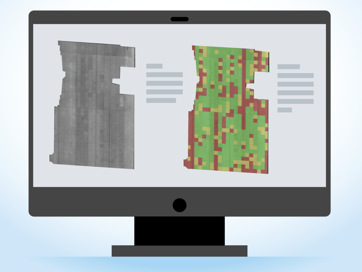
Reference image showing how the software categorizes each runway zone by pavement condition. Green denotes good condition, yellow signals early deterioration, and red flags damaged pavement.
The AI processes all the gathered data and delivers two key outputs:
1.- Zone-based deterioration map: It classifies each pavement section into one of three categories using a traffic-light scale: green for good condition, yellow for early wear, and red for critical areas.
2.-Geo-referenced report: identifies likely causes of the damage and recommends specific repair or rehabilitation actions.
This system not only evaluates runway conditions faster and more accurately without disrupting air traffic, but also paves the way for a paradigm shift: moving from corrective to preventive maintenance. By identifying issues before they worsen, it enables more targeted and efficient interventions.
Although still under development, the researchers foresee applying this technology to other infrastructure such as highways, city streets, and haul roads at mining sites, helping make pavement management smarter and more sustainable.
Smart diagnosis and recommendations

Department of Construction Engineering and Management