Date of publication
Undergrad Researcher
Salomé Palacios
Student of Engineering and Environmental Sciences
Mentor
Megan Williams
Department of Hydraulic and Environmental Engineering
Faculty of Biological Sciences
Associated Contents

Related Areas

Portada » Between the River and the Sea: the visible footprint of climate change on the Chilean coast
Between the River and the Sea: the visible footprint of climate change on the Chilean coast

Salomé Palacios
Student of Engineering and Environmental Sciences
Share:
When we look at the Chilean coast, it’s easy to be captivated by its beauty: beaches, cliffs, wetlands, and a sea that changes color with the seasons. But behind that calm appearance lie complex dynamics that connect the continent with the ocean, and that are fundamental for life.
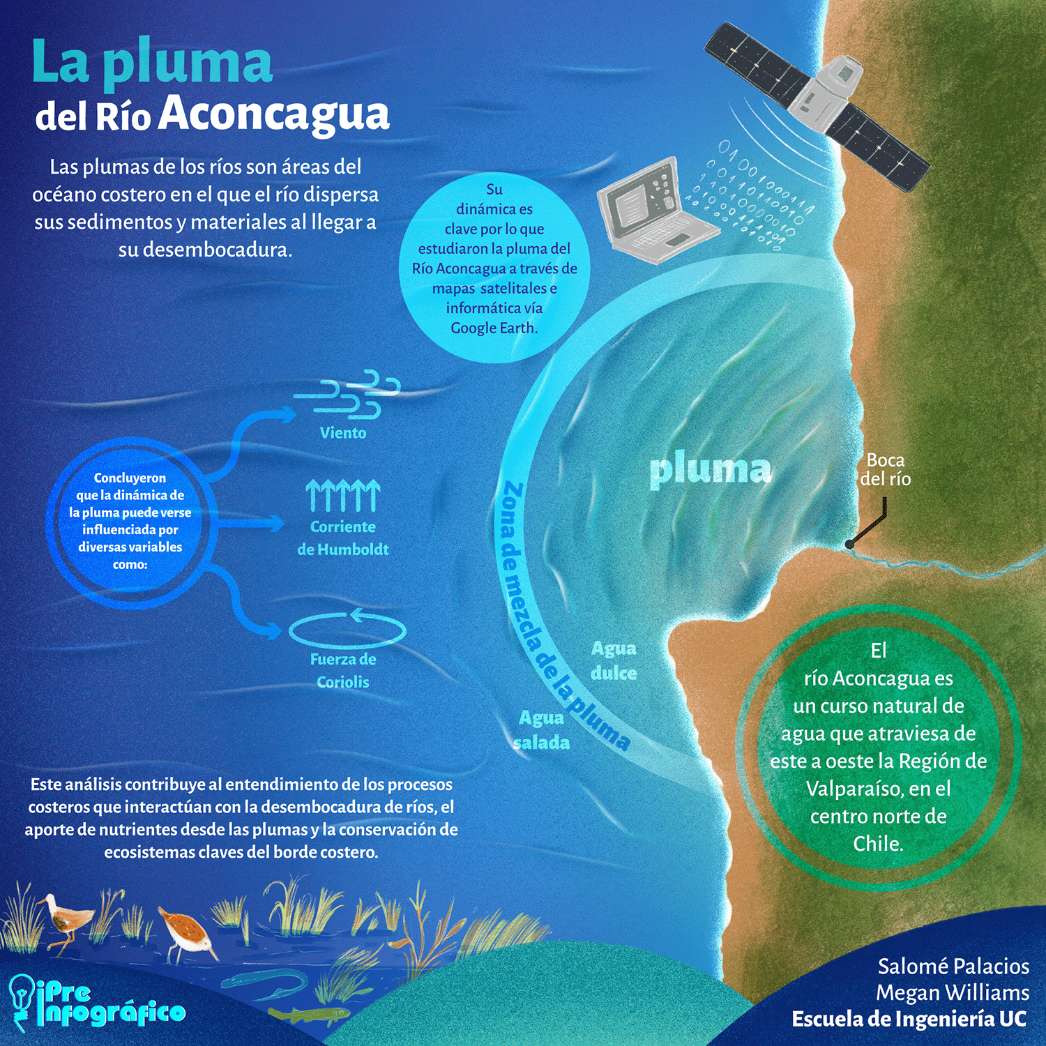
One of these phenomena are river plumes: large tongues of murky water that extend into the sea from river mouths. Although they are often associated with pollution, plumes play essential ecological roles. They transport sediments, nutrients, and organic matter that enrich not only coastal waters but also nearby wetlands, nourishing these ecosystems with the necessary elements to sustain life.
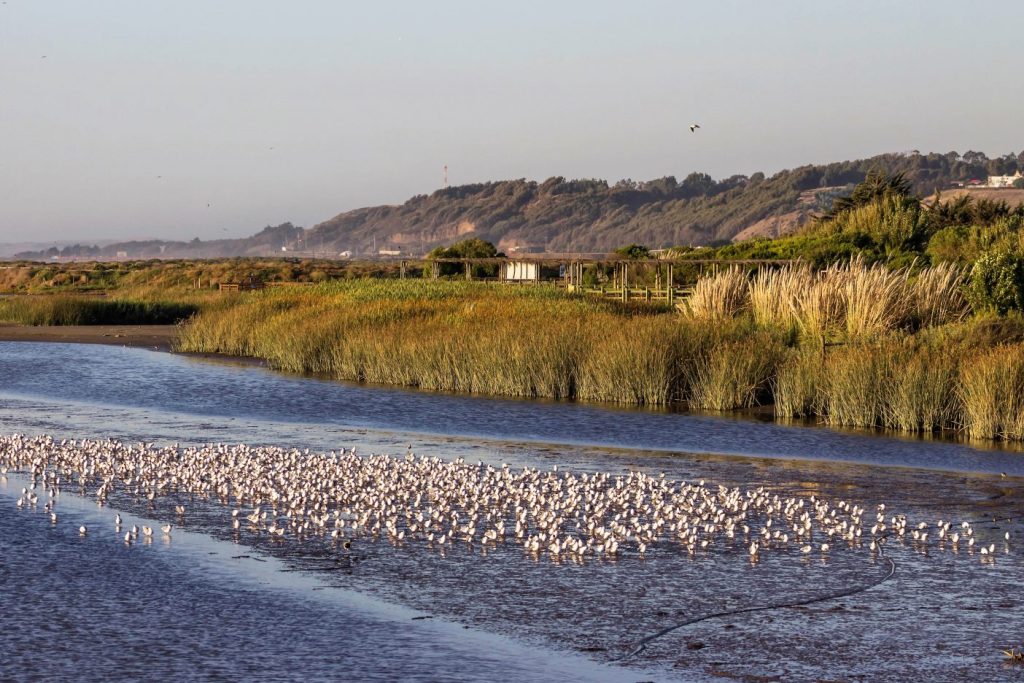
At the heart of this dynamic is the Aconcagua River, one of the most important rivers in central Chile. It originates in the Andes Mountains and travels over 140 kilometers before emptying into the Pacific Ocean in the municipality of Concón. At this point, the river not only delivers its waters to the sea, but also gives rise to a coastal wetland of great ecological value, officially declared an urban wetland in 2022. This unique ecosystem, where freshwater and saltwater mix, is home to rich biodiversity and also acts as a natural barrier against disasters such as storm surges and flooding.
Aware of the increasing threat that climate change represents for coastal ecosystems, Environmental Engineering and Science student Salomé Palacios joined a research project led by Professor Megan Williams from the Department of Hydraulic and Environmental Engineering and the Faculty of Biological Sciences. The goal was to investigate how the Aconcagua River plumes have changed in recent years. Factors such as heavy rainfall, prolonged droughts, and changes in coastal wind patterns have altered the frequency, direction, and composition of these plumes, directly impacting the wetland and its biodiversity. To understand these changes and anticipate their consequences, the team turned to a powerful but underutilized tool in this field: satellite imagery — an exceptional window into the large-scale and long-term evolution of these phenomena.
Plumes from space
The images used in this study were taken between 2021 and 2024 by the Landsat 8 and 9 satellites, operated by NASA and the United States Geological Survey (USGS). These satellites provide open and free Earth observation data, available both to researchers and to the public. Thanks to this accessibility, they have become key tools for large-scale environmental monitoring.
Of the 130 images collected, the researchers selected 40 that had good visibility — free of cloud cover — to better analyze the formation and behavior of the plumes at the mouth of the Aconcagua River.
Using the Google Earth Engine platform and geospatial analysis techniques, the research team was able to identify and characterize the plumes based on their size, direction, and frequency. They used a specific spectral band from the satellites known as the “green band” (B3), which detects green wavelengths and is especially useful for observing vegetation and suspended sediments in water. They also applied the Normalized Difference Turbidity Index (NDTI), which helps estimate water turbidity. By combining both methods, they were able to detect precisely where the plumes formed, how extensive they were, and how they changed over time.
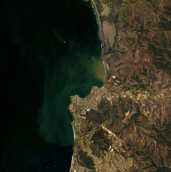
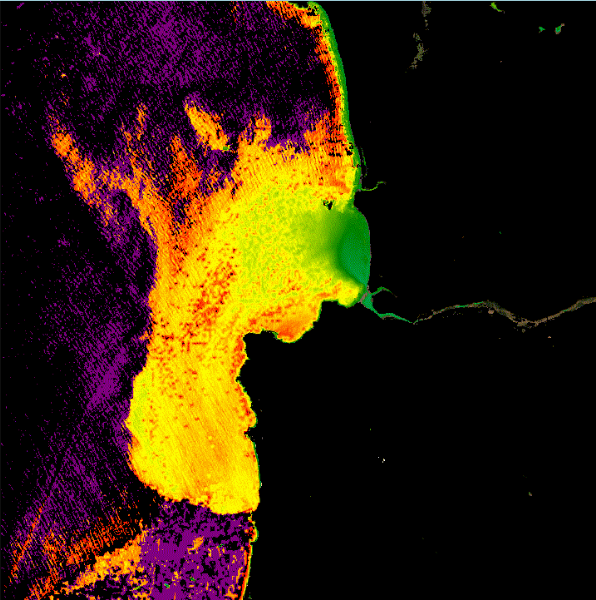
Satellite images of the plume generated at the mouth of the Aconcagua River, observed using two approaches: RGB (left) and NTDi (right).
To better understand why plumes form and how they behave, the satellite analysis was complemented with meteorological and hydrological data from the area: flow rate of the Aconcagua River, tide levels, rainfall, wind speed and direction, and the presence of the El Niño climate phenomenon. This provided a broader view of the forces behind these dynamics and their effects on coastal ecosystems.
El Niño increases sediment flow
Through satellite analysis and comparison with climate and river data, the study found a significant trend in the behavior of the river plumes in recent years. For example, in 2021, 8 plume events were observed at the mouth of the Aconcagua River, but in 2022, only 4 were recorded. In 2023, however, the trend reversed: there were 19 plumes recorded, and by October 2024, 9 events had already occurred — suggesting a possible stabilization compared to the previous year.
This increase coincided with the return of the El Niño phenomenon in 2023 and revealed a clear pattern: from that year on, the plumes became not only more frequent but also larger. In some cases, they covered areas greater than 100 million square meters. This behavior is linked to increased rainfall, greater river discharge, and changes in coastal winds.
The importance of direction and turbidity
Another key finding was how strongly the direction and extent of the plumes were influenced by wind conditions. When winds were strong, the plumes tended to follow the wind direction. On calmer days, their movement was dominated by the Humboldt Current and the Coriolis effect, which in the Southern Hemisphere deflects water masses to the left.
In addition to wind conditions, currents, and water composition, plume behavior is also related to factors such as weather and river flow. The researchers found significant variation in water turbidity in the plumes — that is, how clear or murky the water appeared. This depended on the type of material carried by the river: in some cases, the suspended matter came mainly from mineral sediments dragged by rainfall and soil erosion, while in others, organic matter from the wetland itself was predominant.
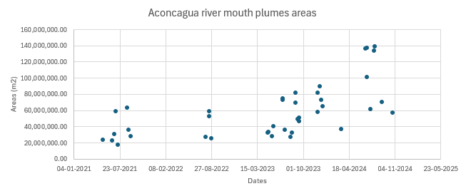
The plumes that form at the river mouth expand more and more over time.
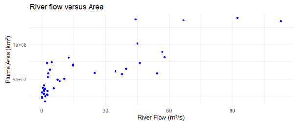
As river flow increases, so does the size of the observed columns. However, when the flow exceeds 15 m³/s, these columns appear less frequently.
Date of publication
Undergrad Researcher
Salomé Palacios
Student of Engineering and Environmental Sciences
Mentor
Megan Williams
Department of Hydraulic and Environmental Engineering
Faculty of Biological Sciences
Associated Contents
Related Areas
River plumes are not just murky patches in the sea — they are visible indicators of what is happening in our watersheds, wetlands, and oceans. Their increasing frequency and size in recent years, linked to phenomena like El Niño and climate change, warn of profound effects on coastal biodiversity and on the delicate balance of ecosystems as sensitive as the Aconcagua River mouth wetland. This research highlights the value of combining satellite technology, environmental analysis, and constant monitoring to understand and anticipate these changes. Protecting coastal ecosystems also means protecting the human communities that depend on them. Observing river plumes is, ultimately, observing how we relate to water, climate, and our territory.
River plumes: a sign of change
Salomé Palacios
Student of Engineering and Environmental Sciences
